Bursts of Cold Air Moving Through This Weekend, Next Week
Though October has been quite warm compared to average temperatures for the first third of the month, a burst of much colder air will be moving through. It will be brief, but a sharp drop from the warmth enjoyed thus far.
Much of the attention has been on Hurricane Milton this week — and rightfully so. Bordering on Category 4-5 status early Wednesday morning with impact over Florida tonight puts much of the country on alert. And that can monopolize the attention because the weather over the rest of the country has been rather uninteresting.
It has been warmer than average for this time of year in most places and overall rather dry as well. Only some areas in the Northeast have really seen much rainfall.
But there is a bigger change coming this weekend. An upper-level trough in the Gulf of Alaska is challenging the warm upper-level ridge that has found itself across the Western United States up into central Canada this week. The first impulse of that will bring a cold front through the northern tier of the country Thursday and Friday. Temperatures will drop marginally, but for the Dakotas it could be significant. Temperatures Wednesday and Thursday will be in the 80s Fahrenheit, and a few 90s could creep into South Dakota. But high temperatures on Friday are likely to be in the 60s or lower 70s. A few showers may occur with the front across the Northern Plains, but it should be mostly dry.
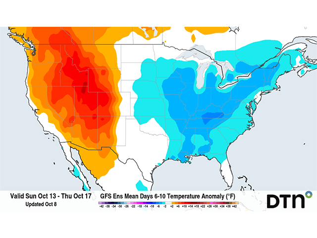
A much bigger change comes with another impulse from that upper trough in the Gulf of Alaska this weekend. It will send a system from the Canadian Prairies on Saturday through the Great Lakes on Sunday, almost like a clipper system we would see during the winter. True enough, the cold front will sweep south through the U.S. and a secondary burst of cold air will follow about a day behind it, getting down to the Gulf of Mexico by Tuesday. True to a clipper system, there won’t be a lot of precipitation, though scattered showers will move through the Great Lakes area. Also like a clipper, the cold air moving over the warm waters in the Great Lakes should mean some lake-effect showers for Monday and Tuesday. It will be too warm to produce snow, which I am sure folks living in the region are rejoicing over; but that just goes to show just how much colder this air mass is likely to be.
Models have been increasing the intensity of the colder air in recent days, and forecasts are likely to change by a few degrees in days ahead. But drops in temperatures of some 20-30 degrees are forecast behind the main front that sweeps through this weekend into early next week. Below are the forecast high temperatures for several areas that should see a marked drop with the fronts passing through. Frosts are likely to occur farther south than they have so far, potentially getting down to Kansas, Missouri, and the Ohio Valley early- to mid-next week.
| City, State | Thu 10/10 | Fri 10/11 | Sat 10/12 | Sun 10/13 | Mon 10/14 | Tue 10/15 | Wed 10/16 | Thu 10/17 | Fri 10/18 |
| Fargo, ND | 86 | 66 | 64 | 54 | 50 | 54 | 63 | 68 | 67 |
| Pierre, SD | 90 | 69 | 74 | 60 | 55 | 59 | 70 | 72 | 70 |
| Minneapolis, MN | 84 | 72 | 66 | 58 | 52 | 53 | 61 | 67 | 69 |
| Omaha, NE | 88 | 88 | 79 | 65 | 58 | 57 | 75 | 72 | 75 |
| Wichita, KS | 87 | 90 | 90 | 75 | 65 | 63 | 66 | 74 | 78 |
| St. Louis, MO | 81 | 84 | 85 | 72 | 62 | 58 | 61 | 65 | 71 |
| Green Bay, WI | 70 | 76 | 64 | 56 | 52 | 53 | 58 | 62 | 67 |
| Chicago, IL | 73 | 83 | 68 | 61 | 55 | 54 | 57 | 62 | 68 |
| Indianapolis, IN | 74 | 78 | 80 | 70 | 59 | 54 | 55 | 59 | 65 |
| Nashville, TN | 78 | 76 | 79 | 81 | 65 | 60 | 60 | 62 | 68 |
| Detroit, MI | 62 | 77 | 65 | 64 | 55 | 53 | 55 | 58 | 63 |
The cold will last the longest in the eastern states as an upper-level trough digs in over the Eastern U.S. next week. But the ridge that has been a persistent feature from the West into central Canada will make a resurgence next week and allow temperatures to pop right back up again, with above-average temperatures by the middle of next week for the Plains and later in the week farther east.
To find more weather conditions and your local forecast from DTN, head over to https://www.dtnpf.com/agriculture/web/ag/weather/interactive-map
John Baranick can be reached at john.baranick@dtn.com