Cold Temperatures Another Weather Factor for Canadian Prairies
The active pattern has brought areas of rain through the Canadian Prairies and continues through the weekend and likely early next week. But the bigger concern will be colder temperatures that will produce frosts and a limited chance for snow.
Drought reduction was the case again this week as a couple of storm systems and disturbances moved through the Canadian Prairies with better rainfall than forecast. Outside of some pockets here and there, and a larger one in southeastern Saskatchewan, rainfall amounts over the last seven days have been near or over 20 millimeters (0.8 inches) through most of the region. Despite this, Manitoba and Saskatchewan both posted some decent seeding numbers in their crop reports this week. Alberta’s was not released as of this writing. Northern, wooded areas will see some benefit as the rain battles wildfires that brought some smoke through the region and into the northern U.S. at times this week. But Saskatchewan is still behind the normal seeding pace and could use some drier and warmer weather to get out into the field. Adjacent areas in northwestern Manitoba and eastern Alberta probably could use the same conditions to accelerate progress.
Unfortunately, that won’t be the case for the next week. A system is wrapping up across the region and instead of progressing eastward like previous disturbances this week, this one will stick around through the weekend and likely still be producing showers in the region on Monday, May 20, and possibly Tuesday, May 21. The storm will favor northern areas with precipitation, while some southern areas will escape the rainfall. Overall, forecast rainfall amounts of 20 to 40 millimeters (0.8 to 1.6 inches) are forecast for northern Alberta and Saskatchewan, with less than 25 millimeters (about 1 inch) across southern areas of those provinces as well as most of Manitoba. Afterward, the main storm track will be pushed south through the U.S. Corn Belt, but some showers may still fall over southern Alberta on May 22. Models are unsure about that.
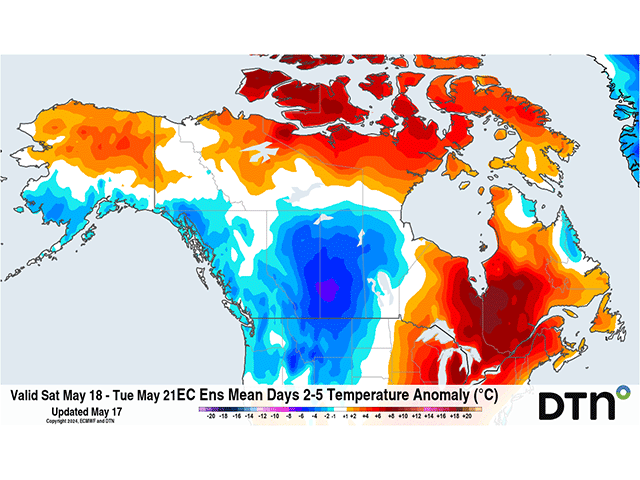
To go along with the rainfall, temperatures are falling significantly. Earlier high temperatures this week in the lower to middle 20s Celsius (70s Fahrenheit) are falling more into the 10s Celsius (50s and 60s Fahrenheit) and some days may dip below that, especially in northern Alberta. The bigger concern than the cooler highs is the colder lows, though. While Manitoba might be able to escape with limited opportunity to hit the freezing mark, western areas and especially northwestern Alberta are likely to go down below freezing several days through next week. While damage is likely to be limited because of how early we are in the growing cycle for most crops, those that plant pulses, soybeans, or canola could have more of an issue with some frost damage and will probably force some producers to hold off additional planting of more sensitive crops. The colder temperatures are also going to limit draining of wet soils, leaving ponded fields a little wetter for longer, another limiting factor for the region.
To find more international weather conditions and your local forecast from DTN, head over to https://www.dtnpf.com/agriculture/web/ag/weather/interactive-map
John Baranick can be reached at john.baranick@dtn.com